

Super Tour
Hike to Lower Blue Mtns most spectacular lookout!
ko0tID2FPUbPVD6Ie17Gd90DYdn1
Hike to Lower Blue Mtns most spectacular lookout!
Grab a coffee and picnic stuff at cute Glenbrook village then walk out to a stunning lookout over an ancient sandstone gorge. Not suitable on hot days
moreGrab a coffee and picnic stuff at cute Glenbrook village then walk out to a stunning lookout over an ancient sandstone gorge. Not suitable on hot days
["https://firebasestorage.googleapis.com/v0/b/freeguides-prod.appspot.com/o/assets%2Ftours%2FXr62sTPv9G82PoFAVphg%2FCopy%20of%20Cover%20photo%20template%20(27).png?alt=media&token=137a462b-756d-459d-b11e-e4424c63c3e9"]
.png)
No items found.
["https://firebasestorage.googleapis.com/v0/b/freeguides-prod.appspot.com/o/assets%2Ftours%2FXr62sTPv9G82PoFAVphg%2FCopy%20of%20Cover%20photo%20template%20(27).png?alt=media&token=137a462b-756d-459d-b11e-e4424c63c3e9"]
[{"address":"5B Burfitt Parade,Glenbrook","location":{"longitudeDelta":0.0030707940459251404,"latitudeDelta":0.0033799244018553054,"latitude":-33.76883020585719,"longitude":150.62129275873303},"media":[{"type":"text","content":"Start at Glenbrook train station. Head up Ross street to check out some cafes and get some provisions if you want to have a picnic. There are more shops on Park Street which intersects with Ross Street. Make sure you have enough water. This walk is not suitable on hot days. "},{"metadata":{"width":1000,"height":662},"type":"img","version":1,"content":"https://firebasestorage.googleapis.com/v0/b/freeguides-prod.appspot.com/o/assets%2Ftours%2FXr62sTPv9G82PoFAVphg%2Fstop_0_1.png?alt=media&token=7f1cbc63-8c31-4c77-aca9-742bd8810be0"}]},{"address":"17 Ross Street,Glenbrook","location":{"longitudeDelta":0.0030707940459251404,"latitudeDelta":0.0033799830959964083,"latitude":-33.76734215662299,"longitude":150.62182718887925},"media":[{"type":"text","content":"Lots of cafes to choose from! There is a fruit shop with fresh salads around the corner on Park Street, and a little IGA."},{"metadata":{"width":720,"height":1600},"type":"img","version":1,"content":"https://firebasestorage.googleapis.com/v0/b/freeguides-prod.appspot.com/o/assets%2Ftours%2FXr62sTPv9G82PoFAVphg%2Fstop_1_1.png?alt=media&token=e323f8db-800d-4264-8674-f03831de22bd"}]},{"address":"Glenbrook Station, Burfitt Pde,Glenbrook","location":{"longitudeDelta":0.0030707940459251404,"latitudeDelta":0.003379920114362278,"latitude":-33.76893890295297,"longitude":150.62152979895473},"media":[{"type":"text","content":"Head back to the station, turn left and start walking along Burfitt Parade which becomes Bruce Road. The train line should now be on your right. Bruce Road winds around a couple of times before crossing over the train line. If you have come by car, you can drive this bit and park at the entrance to the National Park (stop 4)."},{"metadata":{"width":1000,"height":678},"type":"img","version":1,"content":"https://firebasestorage.googleapis.com/v0/b/freeguides-prod.appspot.com/o/assets%2Ftours%2FXr62sTPv9G82PoFAVphg%2Fstop_2_1.png?alt=media&token=faa9280c-d06a-4ef8-8f95-1e68c69efaec"}]},{"address":"77A Bruce Road,Glenbrook","location":{"longitudeDelta":0.0030707940459251404,"latitudeDelta":0.0033795801049549823,"latitude":-33.777557864937265,"longitude":150.6213024817407},"media":[{"type":"text","content":"You have reached the entrance of the Blue Mountains National Park (Glenbrook end). This is the last place to access fresh water and toilets or dispose of rubbish. Please make sure you have at least 2 litres of water for your walk and a bag to carry your picnic rubbish out of the park. "},{"metadata":{"width":1000,"height":1223},"type":"img","version":1,"content":"https://firebasestorage.googleapis.com/v0/b/freeguides-prod.appspot.com/o/assets%2Ftours%2FXr62sTPv9G82PoFAVphg%2Fstop_3_1.png?alt=media&token=347f67e7-1b7c-46ac-9731-78c550d94b1f"}]},{"address":"Jellybean track Bruce Road,Glenbrook","location":{"longitudeDelta":0.005475394427776337,"latitudeDelta":0.006026466594420299,"latitude":-33.77809624109352,"longitude":150.61998719349504},"media":[{"type":"text","content":"Don't take any of the bush paths yet, just walk along the road as it heads steeply downhill. Check out the pretty honeycombed rock on the way down. "},{"metadata":{"width":1000,"height":1318},"type":"img","version":1,"content":"https://firebasestorage.googleapis.com/v0/b/freeguides-prod.appspot.com/o/assets%2Ftours%2FXr62sTPv9G82PoFAVphg%2Fstop_4_1.png?alt=media&token=7c6ede7e-1558-4c5e-8db4-418d4f4bb137"},{"metadata":{"width":1000,"height":1280},"type":"img","version":1,"content":"https://firebasestorage.googleapis.com/v0/b/freeguides-prod.appspot.com/o/assets%2Ftours%2FXr62sTPv9G82PoFAVphg%2Fstop_4_4.png?alt=media&token=a0603d93-14fc-4bd9-b85f-77d4bb6eee4d"}]},{"address":"The Oaks Trail The Oaks Trail,Blue Mountains National Park","location":{"longitudeDelta":0.005475394427804758,"latitudeDelta":0.0060264106371406,"latitude":-33.77889159165079,"longitude":150.61857802793384},"media":[{"type":"text","content":"You have reached Glenbrook Creek. If National Parks have advised that it is unsafe to cross the creek, or the water level is too high, do not cross!\n\nIf it's safe, cross over and continue walking up the steep road until you get to the first bend. "},{"metadata":{"width":1000,"height":1346},"type":"img","version":1,"content":"https://firebasestorage.googleapis.com/v0/b/freeguides-prod.appspot.com/o/assets%2Ftours%2FXr62sTPv9G82PoFAVphg%2Fstop_5_1.png?alt=media&token=6fd78c4b-de75-4a5b-8895-8b1d7ffb30d6"},{"metadata":{"width":1000,"height":1333},"type":"img","version":1,"content":"https://firebasestorage.googleapis.com/v0/b/freeguides-prod.appspot.com/o/assets%2Ftours%2FXr62sTPv9G82PoFAVphg%2Fstop_5_2.png?alt=media&token=8be8ded3-4939-432a-a007-f97766dde7d8"}]},{"address":"The Oaks Trail The Oaks Trail,Blue Mountains National Park","location":{"longitudeDelta":0.005475394427776337,"latitudeDelta":0.006026270819518231,"latitude":-33.78087882104797,"longitude":150.61810059472919},"media":[{"type":"text","content":"At the first bend up the steep road, a trail heads off into the bush. It's called the Euroka track. Take this track."},{"metadata":{"width":1000,"height":1333},"type":"img","version":1,"content":"https://firebasestorage.googleapis.com/v0/b/freeguides-prod.appspot.com/o/assets%2Ftours%2FXr62sTPv9G82PoFAVphg%2Fstop_6_2.png?alt=media&token=4adba4b0-f502-4608-aaab-153ab6f363ca"}]},{"address":"Euroka Walking Track Euroka Walking Track,Blue Mountains National Park","location":{"longitudeDelta":0.0029239431023597717,"latitudeDelta":0.0032177654547140833,"latitude":-33.78232041438724,"longitude":150.61744479462504},"media":[{"type":"text","content":"Continue following the Euroka walking bush track until it intersects with a fire trail/road in about 20 minutes. From around May to September there are usually a lot of wild flowers along this track."},{"metadata":{"width":1000,"height":750},"type":"img","version":1,"content":"https://firebasestorage.googleapis.com/v0/b/freeguides-prod.appspot.com/o/assets%2Ftours%2FXr62sTPv9G82PoFAVphg%2Fstop_7_1.png?alt=media&token=8d946458-943a-453c-944b-6866da53aef9"},{"metadata":{"width":1000,"height":1333},"type":"img","version":1,"content":"https://firebasestorage.googleapis.com/v0/b/freeguides-prod.appspot.com/o/assets%2Ftours%2FXr62sTPv9G82PoFAVphg%2Fstop_7_2.png?alt=media&token=ba6c9637-bea3-4b7e-a60f-a436eb6733c9"}]},{"address":"Euroka Walking Track Euroka Walking Track,Blue Mountains National Park","location":{"longitudeDelta":0.002293623983860016,"latitudeDelta":0.0025235988631848727,"latitude":-33.79203363636837,"longitude":150.61627199873328},"media":[{"type":"text","content":"When you reach the road, watch out for cars and cyclists. Turn left and walk along the road, following signs to Tunnel View Lookout and Mt Portal. "},{"metadata":{"width":1000,"height":750},"type":"img","version":1,"content":"https://firebasestorage.googleapis.com/v0/b/freeguides-prod.appspot.com/o/assets%2Ftours%2FXr62sTPv9G82PoFAVphg%2Fstop_8_1.png?alt=media&token=459eb1f2-594f-4bfb-9996-03b68ea04b27"}]},{"address":"Euroka Road Euroka Road,Blue Mountains National Park","location":{"longitudeDelta":0.002293623983860016,"latitudeDelta":0.0025235886704848554,"latitude":-33.79237942193362,"longitude":150.6167189218104},"media":[{"type":"text","content":"The map makes this corner look bigger and more complicated than it is! Once you've turned left at the sign to Mt Portal/Tunnel View Lookout you are on the right track. This was a dirt road until very recently. They have just paved it which slightly takes away from the feeling of it being a bush walk, and enabes cars to drive faster, so please listen out for cars. \n\nWatch out for a sign on your right for the Portal Waterhole. This is a nice path that rejoins the road later on. You will pass a permanent waterhole. It's not suitable for drinking or swimming. Once you've reached the waterhole, continue on until the path leads you out onto the road again. Turn right. You will soon start heading up a steep hill. "},{"metadata":{"width":1000,"height":1345},"type":"img","version":1,"content":"https://firebasestorage.googleapis.com/v0/b/freeguides-prod.appspot.com/o/assets%2Ftours%2FXr62sTPv9G82PoFAVphg%2Fstop_9_2.png?alt=media&token=6ab91f9c-033b-4592-b434-216525df8170"}]},{"address":"Mount Portal Trail Mount Portal Trail,Blue Mountains National Park","location":{"longitudeDelta":0.007106177508831024,"latitudeDelta":0.007819351411640696,"latitude":-33.79189953276765,"longitude":150.61779348179698},"media":[{"type":"text","content":"As mentioned in the last stop, you can follow the road as is indicated on the map or you can follow the Portal Waterhole bushtrack which heads off on your right, near here. This path brings you back to the road anyway, and is a pretty alternative."},{"metadata":{"width":1000,"height":1333},"type":"img","version":1,"content":"https://firebasestorage.googleapis.com/v0/b/freeguides-prod.appspot.com/o/assets%2Ftours%2FXr62sTPv9G82PoFAVphg%2Fstop_10_1.png?alt=media&token=2a4fd7e6-88ac-4275-9b42-29eefa7cc4e1"},{"metadata":{"width":1000,"height":1333},"type":"img","version":1,"content":"https://firebasestorage.googleapis.com/v0/b/freeguides-prod.appspot.com/o/assets%2Ftours%2FXr62sTPv9G82PoFAVphg%2Fstop_10_2.png?alt=media&token=6a9b7e1a-f73d-49bb-8fb6-90537ffaeaa0"}]},{"address":"Mount Portal Trail Mount Portal Trail,Blue Mountains National Park","location":{"longitudeDelta":0.007106177508831024,"latitudeDelta":0.007819894691458273,"latitude":-33.78595073426189,"longitude":150.62694853171706},"media":[{"type":"text","content":"The road rises steeply and near the top at a bend you will see off to your left a sign pointing to Tunnel View Lookout. You are only 200 metres away now! Follow the signs to the Lookout. Be extremely careful near the edges, the unfenced cliffs are sheer drops of hundreds of metres. Don't risk yourself for a good photo!"},{"metadata":{"width":1000,"height":750},"type":"img","version":1,"content":"https://firebasestorage.googleapis.com/v0/b/freeguides-prod.appspot.com/o/assets%2Ftours%2FXr62sTPv9G82PoFAVphg%2Fstop_11_0.png?alt=media&token=61da04d8-410d-4021-93eb-edb891a5851f"},{"metadata":{"width":1000,"height":1333},"type":"img","version":1,"content":"https://firebasestorage.googleapis.com/v0/b/freeguides-prod.appspot.com/o/assets%2Ftours%2FXr62sTPv9G82PoFAVphg%2Fstop_11_2.png?alt=media&token=f3a1c197-6fa9-44c9-a4de-68d4b034c264"}]},{"address":"Mount Portal Trail Mount Portal Trail,Blue Mountains National Park","location":{"longitudeDelta":0.007106177508831024,"latitudeDelta":0.007820071414670338,"latitude":-33.78401545356276,"longitude":150.62758153304458},"media":[{"type":"text","content":"You've made it to your picnic area and the best Lookout in the Lower Blue Mountains! Please don't go near the edges and pleeeease don't leave any rubbish here, if you've brought picnic items. Entanglement by rubbish is a serious problem for wildlife.\n\nTo the north and north west you can see the high points of Mt Hay, Mt Banks, Mt Wilson, Mt Irvine and Mt Tomah. To the north east you can see Penrith and beyond towards Sydney. Below you is beautiful, ancient Glenbrook Gorge. And directly across the Gorge are the suburbs of Lapstone and Glenbrook. You will notice the train line built into the other side of the Gorge and the trains passing through the tunnel after which this lookout is named."},{"metadata":{"width":1000,"height":1333},"type":"img","version":1,"content":"https://firebasestorage.googleapis.com/v0/b/freeguides-prod.appspot.com/o/assets%2Ftours%2FXr62sTPv9G82PoFAVphg%2Fstop_12_2.png?alt=media&token=3848232d-cdde-46d9-8112-5f7cd595d3d8"},{"type":"text","content":"If you want to add another 2 km (in total) to your walk you can follow signs to Mt Portal for another spectacular lookout over the Nepean River and Sydney. Signs will show you the way, back on the main path/road. Otherwise, retrace your steps all the way back to the start of this walk. Skip the Portal Waterhole on the way back, just stay on the road until you reach the Euroka Walking trail again, turn right onto it, retracing your steps, then down the road, across the creek and back up the steep hill and out of the National Park. I hope you enjoyed our favourite local walk, it's 12km long (from station option) and has an elevation gain of 270 metres. "}]},{"address":"Mount Portal Trail Mount Portal Trail,Blue Mountains National Park","location":{"longitudeDelta":0.001645199954509735,"latitudeDelta":0.0018104675600341125,"latitude":-33.78376752914332,"longitude":150.6276915036142},"media":[{"type":"text","content":"More photos from this beautiful spot on the border lands of Dharug and Gundungurra countries!\n\nExtra tip, if you feel like a swim! On your way back, after you've crossed the creek again, look out for signs to the Blue Pool or the Jellybean Pool. Blue Pool is only a 5 minute walk off the road and Jellybean about 10 minutes off the road. "},{"metadata":{"width":1000,"height":1333},"type":"img","version":1,"content":"https://firebasestorage.googleapis.com/v0/b/freeguides-prod.appspot.com/o/assets%2Ftours%2FXr62sTPv9G82PoFAVphg%2Fstop_13_1.png?alt=media&token=ca6620c0-85ad-4523-8e8f-277d545bd52c"},{"metadata":{"width":1000,"height":1333},"type":"img","version":1,"content":"https://firebasestorage.googleapis.com/v0/b/freeguides-prod.appspot.com/o/assets%2Ftours%2FXr62sTPv9G82PoFAVphg%2Fstop_13_2.png?alt=media&token=ba2e4936-5e3f-483f-833d-112da58c833b"}]}]
5.00
0

Nature
4
hours
33
times run
#
59
Rank
Grab a coffee and picnic stuff at cute Glenbrook village then walk out to a stunning lookout over an ancient sandstone gorge. Not suitable on hot days
5.0
Rating
Nature
4
Hours
33
TOURS COMPLETED
#
59
rank
≈
0 kms
Language
English
Start Location
Tags
This is some text inside of a div block.
On-tour Inclusion and Exclusion
Inclusions
Self-guided
Anytime, Anywhere
Creates by locals
Photo-taking assist
Video-taking assist
Exclusion
Drinking water
Sunglass and skin sunblock
Thank you! Your submission has been received!
Oops! Something went wrong while submitting the form.
8/21/2021

Ken Corbett
21
Aug
,
2021
5
5
A Wonderful walk on a perfect late winter’s day. Really good instruction by Katherine
8/20/2021

Daniel Wasilewsky
20
Aug
,
2021
5
5
Amazing hike! Can't wait to do it in person
Thank you! Your submission has been received!
Oops! Something went wrong while submitting the form.
Preview
[{"address":"5B Burfitt Parade,Glenbrook","location":{"longitudeDelta":0.0030707940459251404,"latitudeDelta":0.0033799244018553054,"latitude":-33.76883020585719,"longitude":150.62129275873303},"media":[{"type":"text","content":"Start at Glenbrook train station. Head up Ross street to check out some cafes and get some provisions if you want to have a picnic. There are more shops on Park Street which intersects with Ross Street. Make sure you have enough water. This walk is not suitable on hot days. "},{"metadata":{"width":1000,"height":662},"type":"img","version":1,"content":"https://firebasestorage.googleapis.com/v0/b/freeguides-prod.appspot.com/o/assets%2Ftours%2FXr62sTPv9G82PoFAVphg%2Fstop_0_1.png?alt=media&token=7f1cbc63-8c31-4c77-aca9-742bd8810be0"}]},{"address":"17 Ross Street,Glenbrook","location":{"longitudeDelta":0.0030707940459251404,"latitudeDelta":0.0033799830959964083,"latitude":-33.76734215662299,"longitude":150.62182718887925},"media":[{"type":"text","content":"Lots of cafes to choose from! There is a fruit shop with fresh salads around the corner on Park Street, and a little IGA."},{"metadata":{"width":720,"height":1600},"type":"img","version":1,"content":"https://firebasestorage.googleapis.com/v0/b/freeguides-prod.appspot.com/o/assets%2Ftours%2FXr62sTPv9G82PoFAVphg%2Fstop_1_1.png?alt=media&token=e323f8db-800d-4264-8674-f03831de22bd"}]},{"address":"Glenbrook Station, Burfitt Pde,Glenbrook","location":{"longitudeDelta":0.0030707940459251404,"latitudeDelta":0.003379920114362278,"latitude":-33.76893890295297,"longitude":150.62152979895473},"media":[{"type":"text","content":"Head back to the station, turn left and start walking along Burfitt Parade which becomes Bruce Road. The train line should now be on your right. Bruce Road winds around a couple of times before crossing over the train line. If you have come by car, you can drive this bit and park at the entrance to the National Park (stop 4)."},{"metadata":{"width":1000,"height":678},"type":"img","version":1,"content":"https://firebasestorage.googleapis.com/v0/b/freeguides-prod.appspot.com/o/assets%2Ftours%2FXr62sTPv9G82PoFAVphg%2Fstop_2_1.png?alt=media&token=faa9280c-d06a-4ef8-8f95-1e68c69efaec"}]},{"address":"77A Bruce Road,Glenbrook","location":{"longitudeDelta":0.0030707940459251404,"latitudeDelta":0.0033795801049549823,"latitude":-33.777557864937265,"longitude":150.6213024817407},"media":[{"type":"text","content":"You have reached the entrance of the Blue Mountains National Park (Glenbrook end). This is the last place to access fresh water and toilets or dispose of rubbish. Please make sure you have at least 2 litres of water for your walk and a bag to carry your picnic rubbish out of the park. "},{"metadata":{"width":1000,"height":1223},"type":"img","version":1,"content":"https://firebasestorage.googleapis.com/v0/b/freeguides-prod.appspot.com/o/assets%2Ftours%2FXr62sTPv9G82PoFAVphg%2Fstop_3_1.png?alt=media&token=347f67e7-1b7c-46ac-9731-78c550d94b1f"}]},{"address":"Jellybean track Bruce Road,Glenbrook","location":{"longitudeDelta":0.005475394427776337,"latitudeDelta":0.006026466594420299,"latitude":-33.77809624109352,"longitude":150.61998719349504},"media":[{"type":"text","content":"Don't take any of the bush paths yet, just walk along the road as it heads steeply downhill. Check out the pretty honeycombed rock on the way down. "},{"metadata":{"width":1000,"height":1318},"type":"img","version":1,"content":"https://firebasestorage.googleapis.com/v0/b/freeguides-prod.appspot.com/o/assets%2Ftours%2FXr62sTPv9G82PoFAVphg%2Fstop_4_1.png?alt=media&token=7c6ede7e-1558-4c5e-8db4-418d4f4bb137"},{"metadata":{"width":1000,"height":1280},"type":"img","version":1,"content":"https://firebasestorage.googleapis.com/v0/b/freeguides-prod.appspot.com/o/assets%2Ftours%2FXr62sTPv9G82PoFAVphg%2Fstop_4_4.png?alt=media&token=a0603d93-14fc-4bd9-b85f-77d4bb6eee4d"}]},{"address":"The Oaks Trail The Oaks Trail,Blue Mountains National Park","location":{"longitudeDelta":0.005475394427804758,"latitudeDelta":0.0060264106371406,"latitude":-33.77889159165079,"longitude":150.61857802793384},"media":[{"type":"text","content":"You have reached Glenbrook Creek. If National Parks have advised that it is unsafe to cross the creek, or the water level is too high, do not cross!\n\nIf it's safe, cross over and continue walking up the steep road until you get to the first bend. "},{"metadata":{"width":1000,"height":1346},"type":"img","version":1,"content":"https://firebasestorage.googleapis.com/v0/b/freeguides-prod.appspot.com/o/assets%2Ftours%2FXr62sTPv9G82PoFAVphg%2Fstop_5_1.png?alt=media&token=6fd78c4b-de75-4a5b-8895-8b1d7ffb30d6"},{"metadata":{"width":1000,"height":1333},"type":"img","version":1,"content":"https://firebasestorage.googleapis.com/v0/b/freeguides-prod.appspot.com/o/assets%2Ftours%2FXr62sTPv9G82PoFAVphg%2Fstop_5_2.png?alt=media&token=8be8ded3-4939-432a-a007-f97766dde7d8"}]},{"address":"The Oaks Trail The Oaks Trail,Blue Mountains National Park","location":{"longitudeDelta":0.005475394427776337,"latitudeDelta":0.006026270819518231,"latitude":-33.78087882104797,"longitude":150.61810059472919},"media":[{"type":"text","content":"At the first bend up the steep road, a trail heads off into the bush. It's called the Euroka track. Take this track."},{"metadata":{"width":1000,"height":1333},"type":"img","version":1,"content":"https://firebasestorage.googleapis.com/v0/b/freeguides-prod.appspot.com/o/assets%2Ftours%2FXr62sTPv9G82PoFAVphg%2Fstop_6_2.png?alt=media&token=4adba4b0-f502-4608-aaab-153ab6f363ca"}]},{"address":"Euroka Walking Track Euroka Walking Track,Blue Mountains National Park","location":{"longitudeDelta":0.0029239431023597717,"latitudeDelta":0.0032177654547140833,"latitude":-33.78232041438724,"longitude":150.61744479462504},"media":[{"type":"text","content":"Continue following the Euroka walking bush track until it intersects with a fire trail/road in about 20 minutes. From around May to September there are usually a lot of wild flowers along this track."},{"metadata":{"width":1000,"height":750},"type":"img","version":1,"content":"https://firebasestorage.googleapis.com/v0/b/freeguides-prod.appspot.com/o/assets%2Ftours%2FXr62sTPv9G82PoFAVphg%2Fstop_7_1.png?alt=media&token=8d946458-943a-453c-944b-6866da53aef9"},{"metadata":{"width":1000,"height":1333},"type":"img","version":1,"content":"https://firebasestorage.googleapis.com/v0/b/freeguides-prod.appspot.com/o/assets%2Ftours%2FXr62sTPv9G82PoFAVphg%2Fstop_7_2.png?alt=media&token=ba6c9637-bea3-4b7e-a60f-a436eb6733c9"}]},{"address":"Euroka Walking Track Euroka Walking Track,Blue Mountains National Park","location":{"longitudeDelta":0.002293623983860016,"latitudeDelta":0.0025235988631848727,"latitude":-33.79203363636837,"longitude":150.61627199873328},"media":[{"type":"text","content":"When you reach the road, watch out for cars and cyclists. Turn left and walk along the road, following signs to Tunnel View Lookout and Mt Portal. "},{"metadata":{"width":1000,"height":750},"type":"img","version":1,"content":"https://firebasestorage.googleapis.com/v0/b/freeguides-prod.appspot.com/o/assets%2Ftours%2FXr62sTPv9G82PoFAVphg%2Fstop_8_1.png?alt=media&token=459eb1f2-594f-4bfb-9996-03b68ea04b27"}]},{"address":"Euroka Road Euroka Road,Blue Mountains National Park","location":{"longitudeDelta":0.002293623983860016,"latitudeDelta":0.0025235886704848554,"latitude":-33.79237942193362,"longitude":150.6167189218104},"media":[{"type":"text","content":"The map makes this corner look bigger and more complicated than it is! Once you've turned left at the sign to Mt Portal/Tunnel View Lookout you are on the right track. This was a dirt road until very recently. They have just paved it which slightly takes away from the feeling of it being a bush walk, and enabes cars to drive faster, so please listen out for cars. \n\nWatch out for a sign on your right for the Portal Waterhole. This is a nice path that rejoins the road later on. You will pass a permanent waterhole. It's not suitable for drinking or swimming. Once you've reached the waterhole, continue on until the path leads you out onto the road again. Turn right. You will soon start heading up a steep hill. "},{"metadata":{"width":1000,"height":1345},"type":"img","version":1,"content":"https://firebasestorage.googleapis.com/v0/b/freeguides-prod.appspot.com/o/assets%2Ftours%2FXr62sTPv9G82PoFAVphg%2Fstop_9_2.png?alt=media&token=6ab91f9c-033b-4592-b434-216525df8170"}]},{"address":"Mount Portal Trail Mount Portal Trail,Blue Mountains National Park","location":{"longitudeDelta":0.007106177508831024,"latitudeDelta":0.007819351411640696,"latitude":-33.79189953276765,"longitude":150.61779348179698},"media":[{"type":"text","content":"As mentioned in the last stop, you can follow the road as is indicated on the map or you can follow the Portal Waterhole bushtrack which heads off on your right, near here. This path brings you back to the road anyway, and is a pretty alternative."},{"metadata":{"width":1000,"height":1333},"type":"img","version":1,"content":"https://firebasestorage.googleapis.com/v0/b/freeguides-prod.appspot.com/o/assets%2Ftours%2FXr62sTPv9G82PoFAVphg%2Fstop_10_1.png?alt=media&token=2a4fd7e6-88ac-4275-9b42-29eefa7cc4e1"},{"metadata":{"width":1000,"height":1333},"type":"img","version":1,"content":"https://firebasestorage.googleapis.com/v0/b/freeguides-prod.appspot.com/o/assets%2Ftours%2FXr62sTPv9G82PoFAVphg%2Fstop_10_2.png?alt=media&token=6a9b7e1a-f73d-49bb-8fb6-90537ffaeaa0"}]},{"address":"Mount Portal Trail Mount Portal Trail,Blue Mountains National Park","location":{"longitudeDelta":0.007106177508831024,"latitudeDelta":0.007819894691458273,"latitude":-33.78595073426189,"longitude":150.62694853171706},"media":[{"type":"text","content":"The road rises steeply and near the top at a bend you will see off to your left a sign pointing to Tunnel View Lookout. You are only 200 metres away now! Follow the signs to the Lookout. Be extremely careful near the edges, the unfenced cliffs are sheer drops of hundreds of metres. Don't risk yourself for a good photo!"},{"metadata":{"width":1000,"height":750},"type":"img","version":1,"content":"https://firebasestorage.googleapis.com/v0/b/freeguides-prod.appspot.com/o/assets%2Ftours%2FXr62sTPv9G82PoFAVphg%2Fstop_11_0.png?alt=media&token=61da04d8-410d-4021-93eb-edb891a5851f"},{"metadata":{"width":1000,"height":1333},"type":"img","version":1,"content":"https://firebasestorage.googleapis.com/v0/b/freeguides-prod.appspot.com/o/assets%2Ftours%2FXr62sTPv9G82PoFAVphg%2Fstop_11_2.png?alt=media&token=f3a1c197-6fa9-44c9-a4de-68d4b034c264"}]},{"address":"Mount Portal Trail Mount Portal Trail,Blue Mountains National Park","location":{"longitudeDelta":0.007106177508831024,"latitudeDelta":0.007820071414670338,"latitude":-33.78401545356276,"longitude":150.62758153304458},"media":[{"type":"text","content":"You've made it to your picnic area and the best Lookout in the Lower Blue Mountains! Please don't go near the edges and pleeeease don't leave any rubbish here, if you've brought picnic items. Entanglement by rubbish is a serious problem for wildlife.\n\nTo the north and north west you can see the high points of Mt Hay, Mt Banks, Mt Wilson, Mt Irvine and Mt Tomah. To the north east you can see Penrith and beyond towards Sydney. Below you is beautiful, ancient Glenbrook Gorge. And directly across the Gorge are the suburbs of Lapstone and Glenbrook. You will notice the train line built into the other side of the Gorge and the trains passing through the tunnel after which this lookout is named."},{"metadata":{"width":1000,"height":1333},"type":"img","version":1,"content":"https://firebasestorage.googleapis.com/v0/b/freeguides-prod.appspot.com/o/assets%2Ftours%2FXr62sTPv9G82PoFAVphg%2Fstop_12_2.png?alt=media&token=3848232d-cdde-46d9-8112-5f7cd595d3d8"},{"type":"text","content":"If you want to add another 2 km (in total) to your walk you can follow signs to Mt Portal for another spectacular lookout over the Nepean River and Sydney. Signs will show you the way, back on the main path/road. Otherwise, retrace your steps all the way back to the start of this walk. Skip the Portal Waterhole on the way back, just stay on the road until you reach the Euroka Walking trail again, turn right onto it, retracing your steps, then down the road, across the creek and back up the steep hill and out of the National Park. I hope you enjoyed our favourite local walk, it's 12km long (from station option) and has an elevation gain of 270 metres. "}]},{"address":"Mount Portal Trail Mount Portal Trail,Blue Mountains National Park","location":{"longitudeDelta":0.001645199954509735,"latitudeDelta":0.0018104675600341125,"latitude":-33.78376752914332,"longitude":150.6276915036142},"media":[{"type":"text","content":"More photos from this beautiful spot on the border lands of Dharug and Gundungurra countries!\n\nExtra tip, if you feel like a swim! On your way back, after you've crossed the creek again, look out for signs to the Blue Pool or the Jellybean Pool. Blue Pool is only a 5 minute walk off the road and Jellybean about 10 minutes off the road. "},{"metadata":{"width":1000,"height":1333},"type":"img","version":1,"content":"https://firebasestorage.googleapis.com/v0/b/freeguides-prod.appspot.com/o/assets%2Ftours%2FXr62sTPv9G82PoFAVphg%2Fstop_13_1.png?alt=media&token=ca6620c0-85ad-4523-8e8f-277d545bd52c"},{"metadata":{"width":1000,"height":1333},"type":"img","version":1,"content":"https://firebasestorage.googleapis.com/v0/b/freeguides-prod.appspot.com/o/assets%2Ftours%2FXr62sTPv9G82PoFAVphg%2Fstop_13_2.png?alt=media&token=ba2e4936-5e3f-483f-833d-112da58c833b"}]}]
Included
- Self-Guided experience
- Run anytime, anywhere, 24/7, with your own phone
- Self-Guided experience
Excluded
- Additional expenses such as food and drink
- Transport
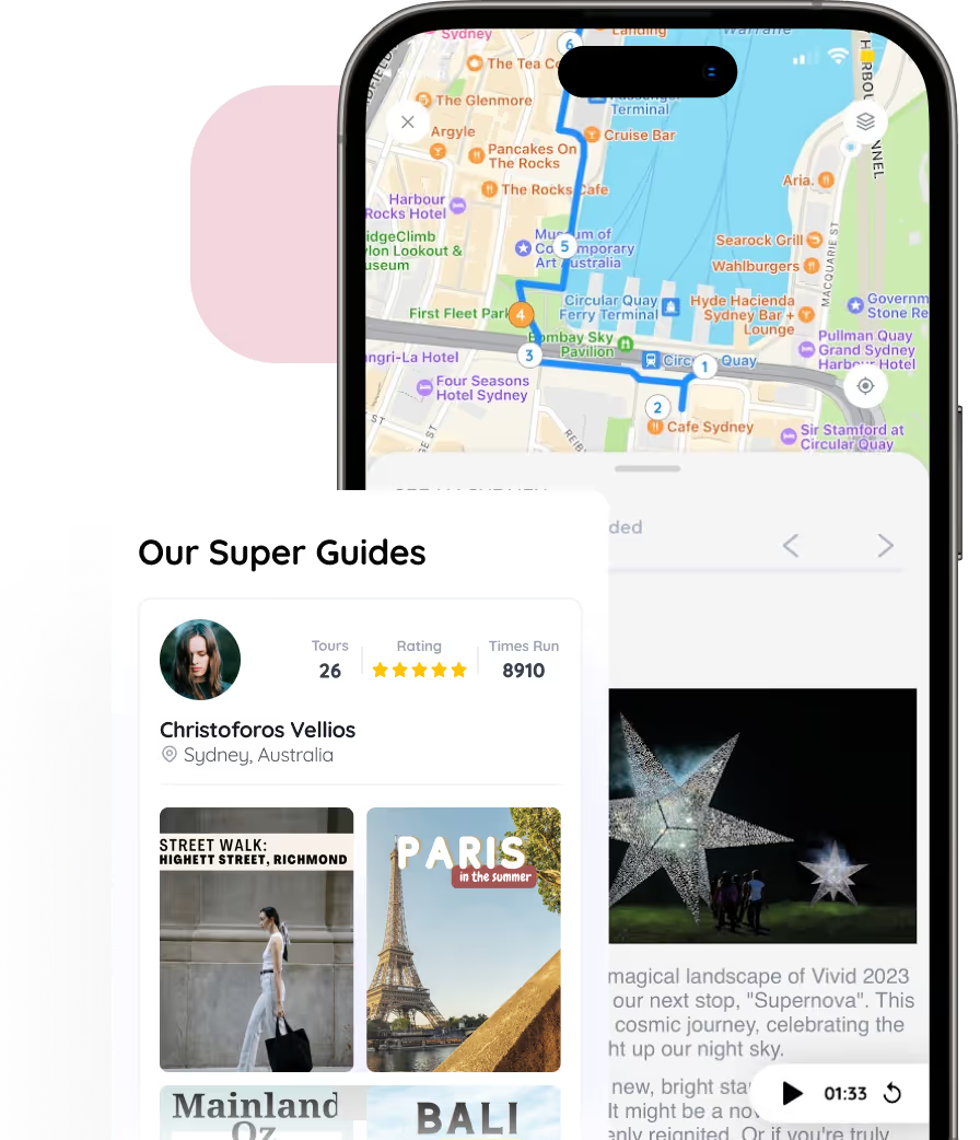
Meet Your Guide
Meet Your Guide

I love experiencing places on foot, it is a great way to see all the detail and really get to know a place.
5
5
No items found.
Thank you! Your submission has been received!
Oops! Something went wrong while submitting the form.
Questions
No questions yet
Similar Experiences

Self-Guided
Use your phone to explore a new city or your own home town.

Anywhere Anytime
You’re the boss. Start the experience virtually or at the start location. Initiate at a time that works for you.

Created by local experts
Each experience is hand made by a real local or organisation who is uniquely knowledgeable.

Extend the relationship with your guests beyond the lobby and into the real world
Follow us on


.svg)
.svg)
.svg)
.svg)
Copyrights ©XXXX FreeGuides. All rights reserved.