


Super Tour
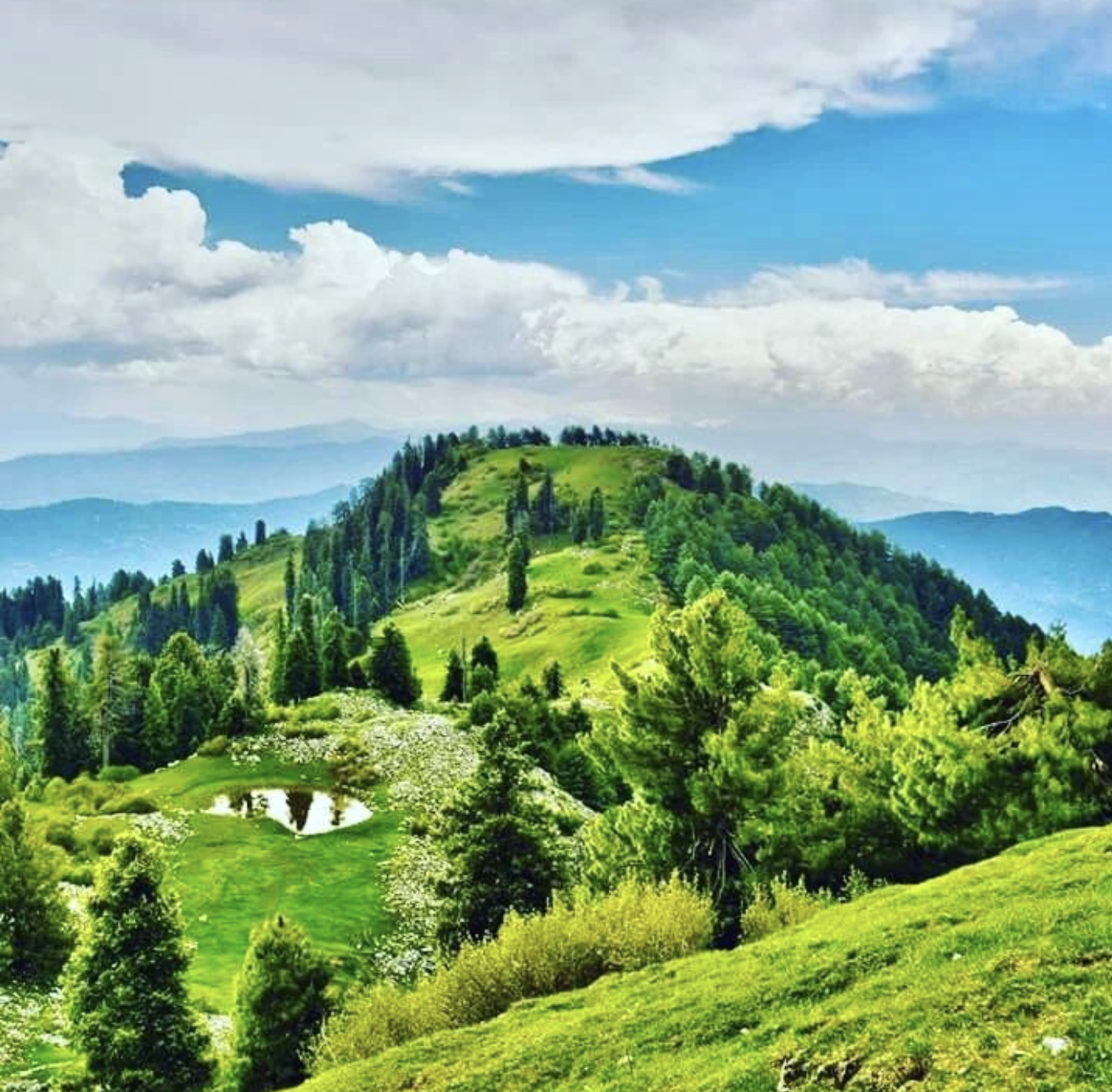
Mushkpuri is a popular mountain peak located in the Nathiagali region of the Abbottabad District of Khyber Pakhtunkhwa, Pakistan. It stands at an altitude of 2,800 metres (9,214 feet). The hike to the peak is a popular activity among tourists and locals alike, and it is often used as a base camp for treks to nearby peaks such as Miranjani and Pir Chanasi.
moreMushkpuri is a popular mountain peak located in the Nathiagali region of the Abbottabad District of Khyber Pakhtunkhwa, Pakistan. It stands at an altitude of 2,800 metres (9,214 feet). The hike to the peak is a popular activity among tourists and locals alike, and it is often used as a base camp for treks to nearby peaks such as Miranjani and Pir Chanasi.
["https://firebasestorage.googleapis.com/v0/b/freeguides-prod.appspot.com/o/assets%2Ftours%2FiRpl76FuDKUB7CZ8EHNm%2FIMG_2152.PNG?alt=media&token=18cdfee9-2eec-4054-8373-29043526ef1d","https://firebasestorage.googleapis.com/v0/b/freeguides-prod.appspot.com/o/assets%2Ftours%2FiRpl76FuDKUB7CZ8EHNm%2FIMG_2153.PNG?alt=media&token=e63753ae-0938-4240-b3c1-b7856d8dd013","https://firebasestorage.googleapis.com/v0/b/freeguides-prod.appspot.com/o/assets%2Ftours%2FiRpl76FuDKUB7CZ8EHNm%2FIMG_2109.png?alt=media&token=c7de7e1f-637d-4338-ac9f-a63f5b851a5d","https://firebasestorage.googleapis.com/v0/b/freeguides-prod.appspot.com/o/assets%2Ftours%2FiRpl76FuDKUB7CZ8EHNm%2FIMG_2111.png?alt=media&token=a7ed5399-432b-4279-8c33-da197638259c"]

No items found.
["https://firebasestorage.googleapis.com/v0/b/freeguides-prod.appspot.com/o/assets%2Ftours%2FiRpl76FuDKUB7CZ8EHNm%2FIMG_2152.PNG?alt=media&token=18cdfee9-2eec-4054-8373-29043526ef1d","https://firebasestorage.googleapis.com/v0/b/freeguides-prod.appspot.com/o/assets%2Ftours%2FiRpl76FuDKUB7CZ8EHNm%2FIMG_2153.PNG?alt=media&token=e63753ae-0938-4240-b3c1-b7856d8dd013","https://firebasestorage.googleapis.com/v0/b/freeguides-prod.appspot.com/o/assets%2Ftours%2FiRpl76FuDKUB7CZ8EHNm%2FIMG_2109.png?alt=media&token=c7de7e1f-637d-4338-ac9f-a63f5b851a5d","https://firebasestorage.googleapis.com/v0/b/freeguides-prod.appspot.com/o/assets%2Ftours%2FiRpl76FuDKUB7CZ8EHNm%2FIMG_2111.png?alt=media&token=a7ed5399-432b-4279-8c33-da197638259c"]
[{"address":"Mushkpuri Track Starting Point","location":{"longitudeDelta":0.10218818160659443,"latitudeDelta":0.09219986310369421,"latitude":34.05556846073383,"longitude":73.4134376},"media":[{"type":"video","content":"https://firebasestorage.googleapis.com/v0/b/freeguides-prod.appspot.com/o/assets%2Ftours%2FiRpl76FuDKUB7CZ8EHNm%2FTrim.mp4?alt=media&token=249b25ad-449e-42fa-8f80-01ae723cae0b"},{"type":"img","content":"https://firebasestorage.googleapis.com/v0/b/freeguides-prod.appspot.com/o/assets%2Ftours%2FiRpl76FuDKUB7CZ8EHNm%2FIMG_2123.png?alt=media&token=0476a420-8aea-4457-91ee-1006341af99e"},{"type":"text","content":"Mushkpuri track is one of the most famous and best places to visit in our beautiful country Pakistan's KPK province. The captivating sights of this location can revitalise your mind and soul. Mushkpuri is a Sanskrit word that means \"a place of quietness and peace.\"\n\nIt is a 2,800-meter (9,200-foot) mountain in Abbottabad District's Nathia Gali Hills. Hiking or trekking is one of Mushkpuri's main attractions. It is located in the Nathia Gali section of Ayubia National Park, 90 kilometres (56 miles) north of Islamabad, immediately above Dunga Gali.\n\nMajor Routes: \nThe following are the three major routes to the top of Mushkpuri Hill:\n1. The Dungali Trackway.\n2. The Lalazar Trackway.\n3. Ayubia Trackway is the third option.\n\nAlthough Dungagali is the shortest route, climbing this mountain takes only one hour, whereas others route take almost two and a half hour of hike.\n\nSome fast facts about the stunning hiking track:\n\n1.Mushkpuri is a mountain peak in the Nathia Gali Hills of the western Himalayas, located in the Abbottabad district of Khyber Pakhtunkhwa, Pakistan.\n \n2.It is the second highest peak in the Gali Hills, rising to a height of around 2,900 metres (9,467 feet). \n\n3.The peak is accessible by a moderate two to three hour trek from Dunga Gali, a small hill station in the Gali Hills. \n\n4.The trek up to the summit passes through lush green meadows and dense forests, offering magnificent views of the surrounding mountains and valleys. \n\n5.The Mushkpuri track is a popular hiking destination in the area, with many visitors coming from Islamabad and other cities in the region.\n\n"},{"type":"img","content":"https://firebasestorage.googleapis.com/v0/b/freeguides-prod.appspot.com/o/assets%2Ftours%2FiRpl76FuDKUB7CZ8EHNm%2FIMG_2117.png?alt=media&token=7cb4f1d6-fc7d-4d7c-af4d-14cbb3c25939"},{"type":"video","content":"https://firebasestorage.googleapis.com/v0/b/freeguides-prod.appspot.com/o/assets%2Ftours%2FiRpl76FuDKUB7CZ8EHNm%2F318030555_688610346281524_1212610175362775455_n.mp4?alt=media&token=46086e22-e5b1-4ea5-b576-8f9b18066297"}]},{"address":"3C48+42X","location":{"longitudeDelta":0.10218818160659443,"latitudeDelta":0.09219986310369421,"latitude":34.055751151898185,"longitude":73.41387593769994},"media":[{"type":"video","content":"https://firebasestorage.googleapis.com/v0/b/freeguides-prod.appspot.com/o/assets%2Ftours%2FiRpl76FuDKUB7CZ8EHNm%2F10000000_115846724624791_2252287845469857135_n.mp4?alt=media&token=19f4bc51-fe42-4164-ace3-8b4c001be0b0"},{"type":"img","content":"https://firebasestorage.googleapis.com/v0/b/freeguides-prod.appspot.com/o/assets%2Ftours%2FiRpl76FuDKUB7CZ8EHNm%2FIMG_2124.png?alt=media&token=9d977e3f-5097-4786-90c6-c766ba720c23"},{"type":"text","content":"A two-hour hike from Dunga Gali Bazar takes you through a dense pine forest with meadows at the top. Views of the Jhelum River, Azad Kashmir, and the Line of Control in Indian-controlled Kashmir are enthralling.\n\nA steady 4-kilometer (2.5-mile) ascent begins at Nathia Gali on the mountain's western side. A steep path leads to the bird park on the Dunga Gali side of the hill.\n\nThe hike to the peak is spectacular. It's a flower carpet, lush with greens and brimming with fragmented flowers.\nThis trail also has a lovely variety of trees and flowers. The view from the top is extremely peaceful and soothing.\n\nIn addition, you can take a horse ride as well to the summit instead of walking if you start your journey at Dunga Gali Bazaar.\n"},{"type":"img","content":"https://firebasestorage.googleapis.com/v0/b/freeguides-prod.appspot.com/o/assets%2Ftours%2FiRpl76FuDKUB7CZ8EHNm%2FIMG_2105.png?alt=media&token=e75cc13a-f684-4d45-b7e6-6b56a24fd8d4"},{"type":"video","content":"https://firebasestorage.googleapis.com/v0/b/freeguides-prod.appspot.com/o/assets%2Ftours%2FiRpl76FuDKUB7CZ8EHNm%2F242831181_567234058038109_3042978156768997231_n.mp4?alt=media&token=2dcbc408-d335-48f5-bc3c-031e038a1894"}]},{"address":"3C5F+QG Dunga Gali","location":{"longitudeDelta":0.10218818160659443,"latitudeDelta":0.09219986310369421,"latitude":34.05946755478069,"longitude":73.42386763454944},"media":[{"type":"video","content":"https://firebasestorage.googleapis.com/v0/b/freeguides-prod.appspot.com/o/assets%2Ftours%2FiRpl76FuDKUB7CZ8EHNm%2Ftrim%201.mp4?alt=media&token=e6df830e-b718-437d-b4e0-19408eff3c08"},{"type":"img","content":"https://firebasestorage.googleapis.com/v0/b/freeguides-prod.appspot.com/o/assets%2Ftours%2FiRpl76FuDKUB7CZ8EHNm%2FIMG_2107.png?alt=media&token=620e7105-f692-4752-8aad-908eed6d2f0a"},{"type":"text","content":"The weather in Mushkpuri changes with the seasons. In the winter, Mushkpuri is snow-capped. The beautiful green plains are completely covered in snow. Furthermore, the majestic icy mountains are a sight to behold. \n\nA breathtaking panorama of snowy peaks, foggy mornings, and blooming sunsets is also available. Snow begins to fall in December and January. Summer weather, on the other hand, is pleasant and the best time to visit.\n\nLet’s have a look at some facts:\n\n1.Mushkpuri Track is one of the most popular trekking routes in the region and is known for its beautiful alpine scenery and challenging terrain. \n2.The trek usually takes around five to six hours to complete and is best done with a guide or with someone familiar with the area.\n \n3.The highest point of the Mushkpuri track is known as Dunga Gali, which is about 9,400 ft (2,860 m) above sea level. \n\n4.This point offers spectacular views of the region and is a popular spot for sunrise and sunset views. \n\n5.The trek is also known for its diverse vegetation, which includes a variety of coniferous and deciduous trees. \n\n6.There are also several small lakes and streams along the track, which provide great opportunities for wildlife sighting.\n \n7.The trek is accessible all year round and especially in winters the views are more stunning.\n"},{"type":"img","content":"https://firebasestorage.googleapis.com/v0/b/freeguides-prod.appspot.com/o/assets%2Ftours%2FiRpl76FuDKUB7CZ8EHNm%2FIMG_2113.png?alt=media&token=b91b5b9f-4c98-4c4e-b32e-650cff6f75a5"},{"type":"video","content":"https://firebasestorage.googleapis.com/v0/b/freeguides-prod.appspot.com/o/assets%2Ftours%2FiRpl76FuDKUB7CZ8EHNm%2Fpost.mp4?alt=media&token=4a62681c-0d91-4bef-b66a-3a6ace89215b"}]},{"address":"Mushkpuri Peak","location":{"longitudeDelta":0.10218818160659443,"latitudeDelta":0.09219986310369421,"latitude":34.061394710736174,"longitude":73.43009860000001},"media":[{"type":"video","content":"https://firebasestorage.googleapis.com/v0/b/freeguides-prod.appspot.com/o/assets%2Ftours%2FiRpl76FuDKUB7CZ8EHNm%2Fpeak%20video.mp4?alt=media&token=dae70d0c-d37c-42a0-9f37-e3c38187e228"},{"type":"img","content":"https://firebasestorage.googleapis.com/v0/b/freeguides-prod.appspot.com/o/assets%2Ftours%2FiRpl76FuDKUB7CZ8EHNm%2FIMG_2112.png?alt=media&token=0d6cff50-f191-4381-b570-d86fa6927672"},{"type":"text","content":" It is one of the highest peaks in the region and is located in the Abbottabad District of Khyber Pakhtunkhwa. The peak is a popular tourist spot, known for its scenic views of the surrounding hills and valleys. It is accessible by trekking or horse riding. \n\nThe peak is also known for its lush green meadows and forests. There are several streams and waterfalls in the area, making it an ideal spot for nature lovers and adventurers.\n\nMushkpuri Peak is a popular spot for picnics and scenic views in the beautiful Murree Hill Station of the Khyber Pakhtunkhwa Province in Pakistan. It is the highest peak in the hill station. \n\nThe views from the top are spectacular, with the valley below and the snow-capped mountains in the distance. On a clear day, one can even see the glistening waters of the nearby Lake. There are several hiking trails to the peak, and the hike is not too difficult. \n\nThe journey takes about two hours, depending on your fitness level. Once at the top, you can enjoy the majestic views, have a picnic and take some amazing photographs.\n\nFew quick facts about the peak are:\n\n1.This peak is located at an elevation of 2,900 metres (9,514 feet) above sea level.\n\n2.It is a popular tourist destination for its hiking, camping and picnic spots.\n \n3.Mushkpuri peak is surrounded by lush green meadows and lush pine trees. \n\n4.The peak offers a spectacular view of the nearby hills and valleys. \n\n5.The peak is easily accessible by road, and one can reach the peak within two hours by hiking or horse riding. \n\n6.The trail to the peak is well marked and easy to follow. \n\n7.At the top of the peak, one can find a picnic spot that is ideal for a family day out. \n\n8.The area is full of lush green grass, wildflowers and plenty of space for camping and picnicking. \n\n9.There are also several restaurants and tea stalls around the peak which provide delicious food and refreshment. \n\n10.The peak is a great spot for taking photos and admiring the breathtaking views of the surrounding areas.\n"},{"type":"img","content":"https://firebasestorage.googleapis.com/v0/b/freeguides-prod.appspot.com/o/assets%2Ftours%2FiRpl76FuDKUB7CZ8EHNm%2FIMG_2121.png?alt=media&token=85a45314-71af-47e0-9e29-2e4cbe84e64f"},{"type":"video","content":"https://firebasestorage.googleapis.com/v0/b/freeguides-prod.appspot.com/o/assets%2Ftours%2FiRpl76FuDKUB7CZ8EHNm%2Fpeak.mp4?alt=media&token=b9102bd9-d558-48c7-92e3-81c9c37724e9"},{"type":"img","content":"https://firebasestorage.googleapis.com/v0/b/freeguides-prod.appspot.com/o/assets%2Ftours%2FiRpl76FuDKUB7CZ8EHNm%2FIMG_2108.png?alt=media&token=9223a69e-e800-4834-b855-56b02a5c8f74"}]}]
0

Nature
24
hours
17
times run
#
Rank
Mushkpuri is a popular mountain peak located in the Nathiagali region of the Abbottabad District of Khyber Pakhtunkhwa, Pakistan. It stands at an altitude of 2,800 metres (9,214 feet). The hike to the peak is a popular activity among tourists and locals alike, and it is often used as a base camp for treks to nearby peaks such as Miranjani and Pir Chanasi.
Rating
Nature
24
Hours
17
TOURS COMPLETED
#
rank
≈
0 kms
Language
English
Start Location
Tags
This is some text inside of a div block.
On-tour Inclusion and Exclusion
Inclusions
Self-guided
Anytime, Anywhere
Creates by locals
Photo-taking assist
Video-taking assist
Exclusion
Drinking water
Sunglass and skin sunblock
Thank you! Your submission has been received!
Oops! Something went wrong while submitting the form.
No ratings yet
Thank you! Your submission has been received!
Oops! Something went wrong while submitting the form.
Preview
[{"address":"Mushkpuri Track Starting Point","location":{"longitudeDelta":0.10218818160659443,"latitudeDelta":0.09219986310369421,"latitude":34.05556846073383,"longitude":73.4134376},"media":[{"type":"video","content":"https://firebasestorage.googleapis.com/v0/b/freeguides-prod.appspot.com/o/assets%2Ftours%2FiRpl76FuDKUB7CZ8EHNm%2FTrim.mp4?alt=media&token=249b25ad-449e-42fa-8f80-01ae723cae0b"},{"type":"img","content":"https://firebasestorage.googleapis.com/v0/b/freeguides-prod.appspot.com/o/assets%2Ftours%2FiRpl76FuDKUB7CZ8EHNm%2FIMG_2123.png?alt=media&token=0476a420-8aea-4457-91ee-1006341af99e"},{"type":"text","content":"Mushkpuri track is one of the most famous and best places to visit in our beautiful country Pakistan's KPK province. The captivating sights of this location can revitalise your mind and soul. Mushkpuri is a Sanskrit word that means \"a place of quietness and peace.\"\n\nIt is a 2,800-meter (9,200-foot) mountain in Abbottabad District's Nathia Gali Hills. Hiking or trekking is one of Mushkpuri's main attractions. It is located in the Nathia Gali section of Ayubia National Park, 90 kilometres (56 miles) north of Islamabad, immediately above Dunga Gali.\n\nMajor Routes: \nThe following are the three major routes to the top of Mushkpuri Hill:\n1. The Dungali Trackway.\n2. The Lalazar Trackway.\n3. Ayubia Trackway is the third option.\n\nAlthough Dungagali is the shortest route, climbing this mountain takes only one hour, whereas others route take almost two and a half hour of hike.\n\nSome fast facts about the stunning hiking track:\n\n1.Mushkpuri is a mountain peak in the Nathia Gali Hills of the western Himalayas, located in the Abbottabad district of Khyber Pakhtunkhwa, Pakistan.\n \n2.It is the second highest peak in the Gali Hills, rising to a height of around 2,900 metres (9,467 feet). \n\n3.The peak is accessible by a moderate two to three hour trek from Dunga Gali, a small hill station in the Gali Hills. \n\n4.The trek up to the summit passes through lush green meadows and dense forests, offering magnificent views of the surrounding mountains and valleys. \n\n5.The Mushkpuri track is a popular hiking destination in the area, with many visitors coming from Islamabad and other cities in the region.\n\n"},{"type":"img","content":"https://firebasestorage.googleapis.com/v0/b/freeguides-prod.appspot.com/o/assets%2Ftours%2FiRpl76FuDKUB7CZ8EHNm%2FIMG_2117.png?alt=media&token=7cb4f1d6-fc7d-4d7c-af4d-14cbb3c25939"},{"type":"video","content":"https://firebasestorage.googleapis.com/v0/b/freeguides-prod.appspot.com/o/assets%2Ftours%2FiRpl76FuDKUB7CZ8EHNm%2F318030555_688610346281524_1212610175362775455_n.mp4?alt=media&token=46086e22-e5b1-4ea5-b576-8f9b18066297"}]},{"address":"3C48+42X","location":{"longitudeDelta":0.10218818160659443,"latitudeDelta":0.09219986310369421,"latitude":34.055751151898185,"longitude":73.41387593769994},"media":[{"type":"video","content":"https://firebasestorage.googleapis.com/v0/b/freeguides-prod.appspot.com/o/assets%2Ftours%2FiRpl76FuDKUB7CZ8EHNm%2F10000000_115846724624791_2252287845469857135_n.mp4?alt=media&token=19f4bc51-fe42-4164-ace3-8b4c001be0b0"},{"type":"img","content":"https://firebasestorage.googleapis.com/v0/b/freeguides-prod.appspot.com/o/assets%2Ftours%2FiRpl76FuDKUB7CZ8EHNm%2FIMG_2124.png?alt=media&token=9d977e3f-5097-4786-90c6-c766ba720c23"},{"type":"text","content":"A two-hour hike from Dunga Gali Bazar takes you through a dense pine forest with meadows at the top. Views of the Jhelum River, Azad Kashmir, and the Line of Control in Indian-controlled Kashmir are enthralling.\n\nA steady 4-kilometer (2.5-mile) ascent begins at Nathia Gali on the mountain's western side. A steep path leads to the bird park on the Dunga Gali side of the hill.\n\nThe hike to the peak is spectacular. It's a flower carpet, lush with greens and brimming with fragmented flowers.\nThis trail also has a lovely variety of trees and flowers. The view from the top is extremely peaceful and soothing.\n\nIn addition, you can take a horse ride as well to the summit instead of walking if you start your journey at Dunga Gali Bazaar.\n"},{"type":"img","content":"https://firebasestorage.googleapis.com/v0/b/freeguides-prod.appspot.com/o/assets%2Ftours%2FiRpl76FuDKUB7CZ8EHNm%2FIMG_2105.png?alt=media&token=e75cc13a-f684-4d45-b7e6-6b56a24fd8d4"},{"type":"video","content":"https://firebasestorage.googleapis.com/v0/b/freeguides-prod.appspot.com/o/assets%2Ftours%2FiRpl76FuDKUB7CZ8EHNm%2F242831181_567234058038109_3042978156768997231_n.mp4?alt=media&token=2dcbc408-d335-48f5-bc3c-031e038a1894"}]},{"address":"3C5F+QG Dunga Gali","location":{"longitudeDelta":0.10218818160659443,"latitudeDelta":0.09219986310369421,"latitude":34.05946755478069,"longitude":73.42386763454944},"media":[{"type":"video","content":"https://firebasestorage.googleapis.com/v0/b/freeguides-prod.appspot.com/o/assets%2Ftours%2FiRpl76FuDKUB7CZ8EHNm%2Ftrim%201.mp4?alt=media&token=e6df830e-b718-437d-b4e0-19408eff3c08"},{"type":"img","content":"https://firebasestorage.googleapis.com/v0/b/freeguides-prod.appspot.com/o/assets%2Ftours%2FiRpl76FuDKUB7CZ8EHNm%2FIMG_2107.png?alt=media&token=620e7105-f692-4752-8aad-908eed6d2f0a"},{"type":"text","content":"The weather in Mushkpuri changes with the seasons. In the winter, Mushkpuri is snow-capped. The beautiful green plains are completely covered in snow. Furthermore, the majestic icy mountains are a sight to behold. \n\nA breathtaking panorama of snowy peaks, foggy mornings, and blooming sunsets is also available. Snow begins to fall in December and January. Summer weather, on the other hand, is pleasant and the best time to visit.\n\nLet’s have a look at some facts:\n\n1.Mushkpuri Track is one of the most popular trekking routes in the region and is known for its beautiful alpine scenery and challenging terrain. \n2.The trek usually takes around five to six hours to complete and is best done with a guide or with someone familiar with the area.\n \n3.The highest point of the Mushkpuri track is known as Dunga Gali, which is about 9,400 ft (2,860 m) above sea level. \n\n4.This point offers spectacular views of the region and is a popular spot for sunrise and sunset views. \n\n5.The trek is also known for its diverse vegetation, which includes a variety of coniferous and deciduous trees. \n\n6.There are also several small lakes and streams along the track, which provide great opportunities for wildlife sighting.\n \n7.The trek is accessible all year round and especially in winters the views are more stunning.\n"},{"type":"img","content":"https://firebasestorage.googleapis.com/v0/b/freeguides-prod.appspot.com/o/assets%2Ftours%2FiRpl76FuDKUB7CZ8EHNm%2FIMG_2113.png?alt=media&token=b91b5b9f-4c98-4c4e-b32e-650cff6f75a5"},{"type":"video","content":"https://firebasestorage.googleapis.com/v0/b/freeguides-prod.appspot.com/o/assets%2Ftours%2FiRpl76FuDKUB7CZ8EHNm%2Fpost.mp4?alt=media&token=4a62681c-0d91-4bef-b66a-3a6ace89215b"}]},{"address":"Mushkpuri Peak","location":{"longitudeDelta":0.10218818160659443,"latitudeDelta":0.09219986310369421,"latitude":34.061394710736174,"longitude":73.43009860000001},"media":[{"type":"video","content":"https://firebasestorage.googleapis.com/v0/b/freeguides-prod.appspot.com/o/assets%2Ftours%2FiRpl76FuDKUB7CZ8EHNm%2Fpeak%20video.mp4?alt=media&token=dae70d0c-d37c-42a0-9f37-e3c38187e228"},{"type":"img","content":"https://firebasestorage.googleapis.com/v0/b/freeguides-prod.appspot.com/o/assets%2Ftours%2FiRpl76FuDKUB7CZ8EHNm%2FIMG_2112.png?alt=media&token=0d6cff50-f191-4381-b570-d86fa6927672"},{"type":"text","content":" It is one of the highest peaks in the region and is located in the Abbottabad District of Khyber Pakhtunkhwa. The peak is a popular tourist spot, known for its scenic views of the surrounding hills and valleys. It is accessible by trekking or horse riding. \n\nThe peak is also known for its lush green meadows and forests. There are several streams and waterfalls in the area, making it an ideal spot for nature lovers and adventurers.\n\nMushkpuri Peak is a popular spot for picnics and scenic views in the beautiful Murree Hill Station of the Khyber Pakhtunkhwa Province in Pakistan. It is the highest peak in the hill station. \n\nThe views from the top are spectacular, with the valley below and the snow-capped mountains in the distance. On a clear day, one can even see the glistening waters of the nearby Lake. There are several hiking trails to the peak, and the hike is not too difficult. \n\nThe journey takes about two hours, depending on your fitness level. Once at the top, you can enjoy the majestic views, have a picnic and take some amazing photographs.\n\nFew quick facts about the peak are:\n\n1.This peak is located at an elevation of 2,900 metres (9,514 feet) above sea level.\n\n2.It is a popular tourist destination for its hiking, camping and picnic spots.\n \n3.Mushkpuri peak is surrounded by lush green meadows and lush pine trees. \n\n4.The peak offers a spectacular view of the nearby hills and valleys. \n\n5.The peak is easily accessible by road, and one can reach the peak within two hours by hiking or horse riding. \n\n6.The trail to the peak is well marked and easy to follow. \n\n7.At the top of the peak, one can find a picnic spot that is ideal for a family day out. \n\n8.The area is full of lush green grass, wildflowers and plenty of space for camping and picnicking. \n\n9.There are also several restaurants and tea stalls around the peak which provide delicious food and refreshment. \n\n10.The peak is a great spot for taking photos and admiring the breathtaking views of the surrounding areas.\n"},{"type":"img","content":"https://firebasestorage.googleapis.com/v0/b/freeguides-prod.appspot.com/o/assets%2Ftours%2FiRpl76FuDKUB7CZ8EHNm%2FIMG_2121.png?alt=media&token=85a45314-71af-47e0-9e29-2e4cbe84e64f"},{"type":"video","content":"https://firebasestorage.googleapis.com/v0/b/freeguides-prod.appspot.com/o/assets%2Ftours%2FiRpl76FuDKUB7CZ8EHNm%2Fpeak.mp4?alt=media&token=b9102bd9-d558-48c7-92e3-81c9c37724e9"},{"type":"img","content":"https://firebasestorage.googleapis.com/v0/b/freeguides-prod.appspot.com/o/assets%2Ftours%2FiRpl76FuDKUB7CZ8EHNm%2FIMG_2108.png?alt=media&token=9223a69e-e800-4834-b855-56b02a5c8f74"}]}]
Included
- Self-Guided experience
- Run anytime, anywhere, 24/7, with your own phone
- Self-Guided experience
Excluded
- Additional expenses such as food and drink
- Transport
Meet Your Guide
Meet Your Guide

Hello, My name is Azka Tanveer and I’m passionate about travelling and exploring. I am huge foodie.
No items found.
No items found.
Thank you! Your submission has been received!
Oops! Something went wrong while submitting the form.
Questions
No questions yet
Similar Experiences

Self-Guided
Use your phone to explore a new city or your own home town.

Anywhere Anytime
You’re the boss. Start the experience virtually or at the start location. Initiate at a time that works for you.

Created by local experts
Each experience is hand made by a real local or organisation who is uniquely knowledgeable.

Extend the relationship with your guests beyond the lobby and into the real world
Follow us on


.svg)
.svg)
.svg)
.svg)
Copyrights ©XXXX FreeGuides. All rights reserved.